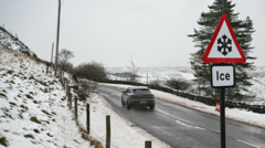
A significant cold snap is expected to affect northern regions of the United Kingdom early this week, as Arctic air sweeps across the country, triggering the threat of ice and snow on the hills.
A yellow weather warning for ice remains in effect until 10:00 GMT on Monday. This alert covers parts of northern and eastern Scotland, as well as Cumbria, Northumberland, and Durham. In these areas, rain, sleet, or hill snow is likely to fall on sub-zero surfaces, creating a high risk of ice on untreated roads, pavements, and cycle paths. The Met Office has warned that difficult driving conditions and injuries from slips and falls are possible.
Alongside the meteorological alerts, the UK Health Security Agency (UKHSA) has issued cold health alerts for north-west England, north-east England, Yorkshire, and the Humber. These alerts, which are aimed at health and social care professionals, remain in force until 21:00 GMT on Thursday.
While the northern half of the UK will start the week with sharp frost and wintry flurries, the south is expected to remain a few degrees above freezing. Temperatures in the south will rebound to above average by midweek. On Monday, most of the UK will see afternoon maximum temperatures between 4 and 8 Celsius, which is slightly below the seasonal norm. Wintry showers are expected in some eastern parts of England and Scotland, falling as sleet or snow over high ground.
A shift in weather patterns is expected later in the day as a front moves in from the south-west, bringing milder air and heavy, persistent rain. As this rain band moves north overnight into Tuesday, a second spell of hill snow is anticipated. A yellow weather warning for snow is set to take effect from midnight until 12:00 GMT on Tuesday. This warning covers the Midlands, north-east and north-west England, Yorkshire and the Humber, and parts of south-west Scotland. Snow depths of 1 to 5 centimetres are likely, with up to 15 centimetres possible in locations above 300-400 metres.
Transport disruptions are forecast for Tuesday, with roads, railways, and bus services potentially experiencing delays. Power cuts are also a possibility in affected areas. Meanwhile, southern parts of the UK will experience blustery conditions and heavy showers. The contrast between the colder, drier north and the milder, wetter south is expected to continue through the middle of the week.

Schools will definitely close Tuesday. Already telling the kids to expect a snowy day off.
Arctic air again? We barely got a chance to store away the heavy winter coats.
Five centimeters of snow is nothing, but the ice on untreated roads is the real killer here.
Wait, is the whole north frozen solid while London is fine? That split feels very uneven lately.
My commute is already a nightmare with this ice. Wish the council would salt the pavements faster.