A developing El Niño phenomenon, which is currently the strongest on record by several metrics, is projected to significantly influence weather patterns across North America during the upcoming autumn and winter. This climate event, characterized by the weakening or reversal of Pacific trade winds and the eastward spread of warm water, releases heat into the atmosphere, altering global weather systems.
Forecasts from the US National Weather Service indicate that the shift of the Pacific jet stream will likely direct rain-bearing systems toward the southern United States, resulting in wetter-than-average conditions. States in the southeast, including Florida, Georgia, and the Carolinas, face the highest probability of above-average rainfall. This pattern mirrors the 1997-1998 El Niño, which caused significant flooding and tornado activity in the region.
California also faces elevated risks, with Governor Gavin Newsom declaring a state of emergency in anticipation of floods and mudslides. The state’s vulnerability is heightened by recent wildfires and rising sea levels, which can be exacerbated by Kelvin waves associated with El Niño, potentially raising coastal levels by up to 15 centimeters. While El Niño winters often bring relief from drought, as seen in 2023-2024, the 2015-2016 event resulted in below-average rainfall for the state.
In contrast, the northern regions, including the northwest US, Northern Plains, Ohio Valley, and western and central Canada, are expected to experience warmer and milder winters. This dryness may lower groundwater levels and increase the risk of spring and summer wildfires, while also reducing snowfall for ski resorts. However, outcomes are not guaranteed, as some historical El Niño winters, such as 1982-1983, resulted in wetter conditions in the northwest.
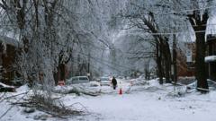
For snow enthusiasts, the impact is mixed. While dry and warm trends may suppress snowfall in the northern US and Canada, increased precipitation in the south could lead to significant snow in the Californian mountains and the southern Rockies. The presence of cold air may also trigger snowfall at lower elevations in the southeastern and eastern US, though freezing rain events are a growing concern, as seen in the 1998 Great Ice Storm. Additionally, the El Niño phenomenon may disrupt the stratospheric polar vortex, potentially allowing cold air to spill across the continent, though this link remains complex and not guaranteed.
How do you trust these long range models when 2015 El Nino brought less rain to California than expected?
Living in Orlando, I am already bracing for the worst. The 1998 comparison is really scaring me lately.
Ski resorts are going to lose their minds if this prediction holds true. No snow means no fun for us powder chasers.